Tuesday, August 16, 2016


Close Encounters of the Monumental Kind

The Trip – Day 18
Dubois, Wyoming – Gillette, Wyoming
393 miles

and

The Trip – Day 19 Part 1
Gillette, Wyoming – Rapid City, South Dakota
Devils Tower, Mt. Rushmore
170 miles 


The day after the Grand Tetons' park trip we traveled from Dubois, through Casper, to Gillette, a gradual downhill drive from the Rockies toward the high plains with the accompanying scenery changing along the way. Wyoming is the least populated state in the country, having less than 600,000 people in an area of over 97,000 square miles. Much of the part we traveled through on Day 18 was Indian reservation or open ranch land, dotted with cattle and antelope. I loved the wide open, hilly feel of the state, and even the ever-present gun shops and constant Second Amendment chatter on talk radio did little to detract from, and probably added to, Wyoming's western beauty.

Driving through Wyoming
In the initial planning of the trip we were to travel this day from Dubois, Wyoming, to Rapid City, South Dakota, where we would spend the night before visiting the Badlands. This would be a 500+ mile day, breaking the 300 mile per day average rule by quite a bit. When I regained my sanity, I booked a hotel for Gillette, Wyoming, still giving us a 300+ mile day, but also allowing a low mileage day after that as well as some flex time for a surprise adventure. My husband had seen a brochure for Devils Tower National Monument sometime during our Wyoming travels and asked if we were passing anywhere near it. I didn't know – it hadn't even been on our long list of parks to visit (though it is technically a national monument and not a park). I looked up the location of Devils Tower and found it to be a short detour off Interstate 90 between Gillette and Rapid City. We decided to leave Gillette early the following morning and make Devils Tower our surprise adventure for the first part of the day, though I suspected I would be dealing with a movie-obsessed husband for much of it. One of my husband's quirks is that he has
Could have been dinner the night before...
the ability to fully enter (Forever!) into the world of any movie that strikes his fancy. (Just ask the kids whom he delights with his dead-on imitation of Darth Vader, kids whose parents weren't even born when my husband first saw Star Wars...) Devils Tower played a prominent role in the plot of the 1977 Steven Spielberg movie Close Encounters of the Third Kind. The night before we were to go to Devils Tower, my husband asked if we could go to a restaurant that served mashed potatoes – lots of 'em – wanting to reenact a scene from the movie. We didn't. He didn't...


Smokey valley or potential alien landing field?


Native American depiction of the tower's formation
There had been wildfires a short distance from Devils Tower* the day before, closing the interstate during the night. I checked the fire status the morning of Day 19 and found the fire mostly contained, so we found ourselves on a somewhat smokey road off the interstate on our way to the tower. The 800+ foot butte could be seen from the distance as we approached. The unique striped and cracked shape of the tower is believed to be the remains of an ancient volcano, the earthen outside of the volcano long ago eroded, leaving only the hardened lava interior. The native American explanation for the vertical crevassed sides involves the climbing of the tower by a huge bear, the stripes around the tower left by its sharp claws. The “park” itself is relatively small, consisting of two concentric main trails, a 1.3 mile one around the base of the tower and a 3+ mile one that could be made longer with some side trails. We had only planned to be here for the morning, so we took the shorter trail around the base, I to get closer views of the tower, my husband to locate the route Roy (Richard Dreyfuss) and Jillian (Melinda Dillon) took in search of aliens. The trail was easy and pleasant, mostly level, mostly paved, and mostly treed. The outside views were of the surrounding valley, slightly hazy with smoke today, and the inside view was of the rocky base of the tower rising to its stripey vertical heights. My husband didn't know where to look first. Was that valley view where the landing pad for the Close Encounters space ship was located? That particular pile of rocks at the base surely must be where Roy and Jillian climbed up to escape the helicopters. Or maybe it was those rocks over there... I could tell it was going to be a long morning.

"Roy and Jillian were here!"
It was a beautiful morning, though. Each side of the tower is different, changing shape as one hikes around it. Being early in the day, the sun would backlight the tower on one side, illuminate it on another. There were deer and prairie dogs and other wildlife in the area including one large extremely photogenic snake. A fellow hiker put his GoPro on the ground a few feet from the snake, and the snake slithered right up to it and passed slowly in front of it like he had been in similar photo ops many times before. We heard voices in the air and looked up to see climbers on the tower, and though far away, the walls of the tower amplified their voices. We took shots of them with the paparazzi zoom and found seven climbers on that section of the tower. 

A very photogenic snake


Three of the climbers

Devils Tower is a popular place for rock climbers. In 1893, a local rancher was the first to climb the tower, constructing a 350 foot ladder of wood, anchored into one of the vertical cracks of the tower. It was used by others for subsequent climbs, and parts of it are still visible today, still wedged into the crevasse. The tower is also a sacred place for native Americans, and some consider climbing the tower disrespectful to their sacred site. There is a
Prayer cloths and prayer bundles
voluntary ban on climbing during the month of June, a time of special traditional tribal ceremonies. Most climbing guides in the area respect this ban, but the climbers we saw the day we were there were either oblivious to the ban or chose to ignore it. There were many tribal prayer bundles and prayer cloths attached to branches of the trees around the base of the tower, with signs along the trail asking to respect their presence and not to touch them. I hope taking photos of them is a way of respecting them...

Remnants of the old ladder (within the larger shaded crevasse to the right)
 

After we completed our trail around the base, after my own personal Roy Neary had obsessed about rocks and aliens and humongous space ships and their possible landing sites, we stopped at the small visitor center where I threatened to embarrass my husband by asking the ranger on duty where the Close Encounters exhibit was. There was none. No mention of the movie at all in the visitor center. We were, however, to find out much later there was a general store outside the park boundary that had a collection of movie memorabilia and DVDs and showed the movie in its entirety every night at 7 pm. Lucky for one of us we didn't know that at the time...

Movie...
Not movie...


* For all the punctuation police out there who have been grinding their teeth, it is, in fact, officially “Devils Tower” and not “Devil's Tower”. When the area was declared a National Monument in 1906, the proclamation inadvertently left out the apostrophe. The National Park Service continues to use “Devils Tower” as the official name.


I know this sounds crazy, but ever since yesterday on the road, I've been seeing this shape. Shaving cream, pillows... Dammit! I know this. I know what this is! This means something. This is important. - Richard Dreyfuss as Roy Neary in Close Encounters of the Third Kind

My husband, the night before the Devils Tower trip...

I guess you've noticed something a little strange with Dad. It's okay, though. I'm still Dad. - Richard Dreyfuss as Roy Neary in Close Encounters of the Third Kind


Too close selfie or alien beings?

Next:

On the Presidential Trail

The Trip – Day 19 Part II
Gillette, Wyoming – Rapid City, South Dakota
Devils Tower, Mt. Rushmore
170 miles


Sunday, August 14, 2016


  Grand! Grand! Grand!
Part II
Stories on the Road

The Trip – Day 17
Rexburg, Idaho – Dubois, Wyoming
The Grand Tetons National Park
195 miles 


One of the main purposes in taking this road trip was to see and experience things we hadn't seen and experienced before. As we traveled across the country, we came to realize we were surrounded by people who are also out to see and experience things they have not seen and experienced before. Yes, there are moments and places where one can be alone in a national park, but those moments can be rare, those places few. At the Grand Canyon and Yosemite, the midday crowds could be intense, with a disappointingly large number of people oblivious to the fact they were sharing shuttles and viewing areas and hiking trails with other people. Many visitors to the parks are selfie-obsessed, with cameras and smart phones aggressively competing for the best vantage points to document one's presence at any given place at any given time (says one half of the couple that generated over 4,000 pictures on this trip...). Still, the quickest and easiest way to positively interact with a person is to offer to take their picture or ask them to take yours. Sharing picnic tables, especially shady ones, is another way to enter into other people's lives. Everyone has a story, and we were surrounded by people willing to share theirs at the right moment. During our visit to the Grand Tetons, we had the opportunity to interface with several of those stories.

 * * *

Chapel of the Transfiguration

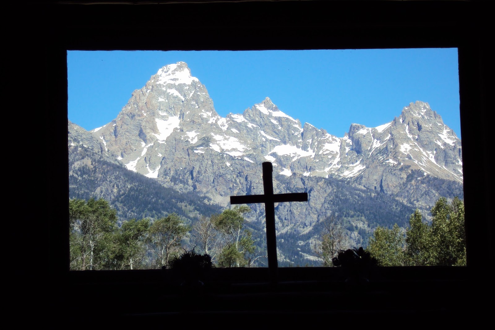
We were on the grounds of the Chapel of the Transfiguration near the Menor's Ferry village and were about to enter the open chapel when a woman, a little younger than a POACA, approached us. Could we not go into the chapel just yet? Her daughter was inside, and unbeknownst to the daughter, her boyfriend had just run back to the car to get the engagement ring he was about to propose to her with. Could we wait outside just for a short while? The woman explained to us that her daughter had been coming to the park since she was a small child, that the chapel was her favorite place in the park. Her fiance was aware of this and wanted to ask her to marry him in that special place. A few other visitors approached, and the woman asked the same of them, if they would wait a few minutes. We all sort of nonchalantly milled around the grounds, pretending to look at posted historic information about the chapel. The boyfriend returned, entered the chapel, and after a short time, exited with a tearfully happy fiancee. Of course, all of us who had been asked to wait had by this time lined the walkway in front of the chapel and applauded the newly engaged couple. When we finally entered the chapel, and saw what made it so special, it already had new meaning for us, having given us the opportunity to, in a small way, be part of a couple's significant moment.


Interior view, chapel stained glass

Looking out the window, behind the altar of the Chapel of the Transfiguration


   * * *

Summer in the west is travel time for motorcyclists, and the national parks are a popular destination for them. We passed many bikers on the roads around the parks (...actually, they passed us...) and we had the opportunity to eat with some of them at the Grand Tetons. Looking for a place to have our backpack lunch before our afternoon hike, we had been lucky enough to find a recently vacated large shaded picnic table in a busy picnic area. A woman, a fellow POACA, carrying a motorcycle helmet, asked if she and her traveling companions could share our table. Of course, we said. She was soon joined by her husband and another couple, helmets in tow, and we had a pleasant lunch together. They were from Kansas, had trailered their motorcycles to South Dakota, and were now touring the Rockies. They had spent the previous night in Yellowstone and were headed to Colorado. They asked about our trip, and my husband shared pictures of some of our adventures, they, in turn, showing us some of their photos. Having been at Yellowstone soon after someone had disappeared into one of the boiling hot springs, they started talking about all the ways one could meet one's demise in the various national parks. This made for a somewhat morbid, but interesting conversation until we parted company, we to do our lake hike, they to continue their ride toward Colorado. Later in the day, when we stopped on the shore of Jackson Lake to take some pictures, we were approached by another biker, who offered to take a picture of both of us.
Would we then take a picture of him and his son? He proudly pointed to a twenty-something guy on a cell phone. He and his son were doing a midwest father-son motorcycle trip together, both biking from the same area of the midwest we had driven from. He told us his son had left a pregnant wife at home with a toddler, and so spent a lot of time on the phone when he could get a signal. After the phone call ended, the two of them posed for a father and son road trip shot and then we all continued on our way.

Photo taken by midwest motorcyclist.  (Jackson Lake in the background)


  * * *


Mt. Moran
The Grand Tetons were also the site of another Oneonta encounter which segued into a poignant story.  We had pulled into an overlook near Mt. Moran and noticed an older (than us) gentleman wearing an Oneonta State wrestling jacket. I told him I knew where that town was, my husband and I had met there, we had graduated from there. His face lit up and he told us he was himself from Pennsylvania, but his nephew was the wrestling coach at Oneonta, and he loved the area, had spent some time there sharing his own wrestling and coaching experience with his nephew. He was friendly and chatty, telling us he was visiting the park with family, commenting on the beautiful view and the glaciers on the mountains. His demeanor subdued slightly as he told us he had always wanted to climb Mt. Moran, the peak in front of us. He shared with us that his brother, a pilot, had died in a plane crash on that mountain years before, that the plane and the remains of all who died in the crash were still up there. He would have liked to honor his brother by climbing the mountain to the crash site, but knew he was too old to do it now. He said the park service doesn't give out information about the crash site because they don't want people hiking up there and disturbing the wreckage of the plane. At this point in his story, a family member called to him from a car, and he said his goodbyes and left. Google was able to finish the story the man in the Oneonta jacket started.* In November, 1950, a New Tribes Mission plane with 21 people on board crashed into Mt. Moran during a snowstorm. There were three pilots on board, one being the brother of the man we had spoken to that day.  Because of the way the plane was wedged into a crevice on the mountain, there was no attempt to salvage the plane or the victims. There was a memorial service on the mountain several months later at the crash site, and today the park service asks that hikers avoid that area in respect for those who are entombed there.


We're all stories, in the end.― Steven Moffat


* For pictures and more details, read: http://www.aircraftwrecks.com/pages/dc3.htm


Next:

Close Encounters of the Monumental Kind

The Trip – Day 18
Dubois, Wyoming – Gillette, Wyoming
393 miles

and

The Trip – Day 19
Gillette, Wyoming – Rapid City, South Dakota
Devils Tower, Mt. Rushmore
170 miles


Friday, August 12, 2016


Grand! Grand! Grand!
 Part I
The Majesty of the Tetons

The Trip – Day 17
Rexburg, Idaho – Dubois, Wyoming
The Grand Tetons National Park
195 miles 


When planning this trip, in paring down the twenty plus parks on our long list of places to visit, it was a toss-up between Yellowstone and the Grand Tetons. The Yellowstone website warned of major road repair during the summer of 2016, and any in-the-park lodging would had to have been booked a year in advance. Fearing a 160 mile traffic jam if we tried to do Yellowstone as a drive-through, we struck it from our list and opted instead to check out the nearby Grand Tetons. Great decision! The Grand Tetons National Park was to become my favorite place on our road trip. It had snow-capped mountains, clear lakes, easy hiking trails, non-stop vistas, and encounters with people who had interesting stories. I've combined two days of travel into a single post twice now, but this is the first time I feel obligated to split one day of travel reporting into two days of posts. Part I will be about the drop-dead beauty of the Grand Teton area itself; Part II will be about people encounters.

"Back" of the Tetons, in Idaho, approaching the Teton Pass
We set out early in the morning from Rexburg, headed toward the Teton Pass, a steep, twisty, non-interstate road that would take us into Jackson, Wyoming, and the entrance to the Grand Tetons National Park. We saw the “back” of the signature Teton peaks approaching us as we drove through what remained of Idaho. A scenic drive itself, this route took us through a river valley before entering the mountain pass overlooking Jackson Hole, the valley below the Grand Tetons. The most iconic section of the Teton range was once a single mountain, but ages of erosion created the craggy individual peaks that exist today. Part of the incredible majesty of the Tetons is that they are viewed from the Snake River “valley” running along their base. Despite the already 6,200+ feet of elevation of the valley, the mountains appear to soar up higher than their 7,000+ feet from the valley floor. That, along with the pine-covered mountains rising into rocky, snow-capped peaks (more accurately, glacier-capped peaks), make for breathtakingly spectacular views. While the red rocks and canyons of Zion and the Grand Canyon had shouted loudly of God's grandeur, as did the granite cliffs and waterfalls of Yosemite, the Grand Tetons speak in a loud hush of His power and beauty and creative ability. ("...awe...some...")


THE Grand Teton
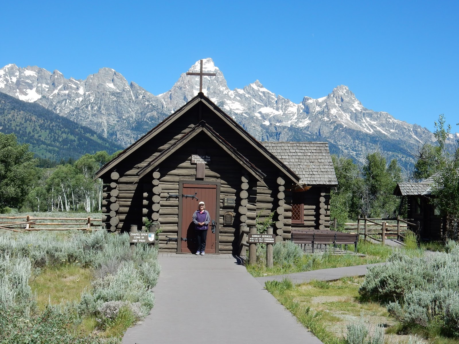
We spent the day driving the length of the park, about 50 miles of non-stop scenic views, going from overlook to overlook, stopping at a tiny historic village, hiking along some of the valley lakes, and soaking in the incredible mountain vistas. The weather was perfect – cool and clear – making for some of the most pleasant hiking of the trip. We started out at a small historic village, Menor's Homestead and Ferry, consisting of a small general store, a cabin, a barn and a few out buildings along the Snake River. There was a replica of the ferry used to take people across the Snake in the early 1900s, one that would be used later in the summer to take visitors across the river in the same fashion. The docent at the general store had just baked a batch of peanut butter cookies in the store's old fashioned oven and was giving out the still-warm treats to the visitors as they came through. The barn housed a covered wagon and other modes of transportation from the era. Nearby the little village was the Chapel of the Transfiguration, a small log cabin church built in the 1920s, still functioning as an Episcopal place of worship each Sunday.


Chapel of the Transfiguration
The ferry
Menor's General Store

Farther up the road we found a picnic area to eat our hikers' lunch and afterward walked along a lake path, a varied, relatively level trail, sometimes wooded, sometimes open, following the shore of long, skinny String Lake, a crystal clear body of water. There were swimmers and kayakers along some sections of it, and nothing but waterbirds along other sections of it, and the endless Teton range along all of it. We walked as far as the rocky stream that joined String Lake to the larger Leigh Lake, sharing the path with canoers who were portaging from one lake to the other. We returned to the picnic area along the same path, but now seeing that mountain range I couldn't get enough of from the opposite direction.


String Lake
Looking toward Leigh Lake

Coulter Bay, off of Jackson Lake
Tailwaters of the Jackson Lake Dam
We did a bit more driving along the park road, traveling up to the Jackson Lake Dam, where the Snake River, having entered the large and beautiful Jackson Lake 15 miles to the north, flows out of the lake before continuing south to Jackson Hole. The tailwaters of the dam were lined with fisherpersons, some women, many with fly rods. This would not be the last time during our trek through Wyoming that I would regret not having stashed a fly rod in the trunk of the car, “just in case”. We continued up Jackson Lake to Coulter Bay Village, a peninsula with a marina and walking trails and more views of the lake and, of course, those ever-present mountains. Alas, it was getting late and we still had 60 miles to drive to our motel, so we had to forego the hike along the peninsula and head east. The drive out away from the park and into the western part of Wyoming was scenic in its own way, weaning us gently off the overwhelming beauty we had been surrounded with all day. The state route followed the Wind River to the small town of Dubois, our stop for the night, screaming “Trout!” most of the way, though my husband didn't seem to hear it. The Trail's End Motel, an old-fashioned log cabin strip motel in Dubois, had a somewhat small, but wonderfully clean and cool room with such a beautiful deck area along the same Wind River (still screaming “Trout!” at me, and now whispering “Fishing without a license doesn't really make you a poacher...”) that I forgave it for the gun shop they had attached to the main lobby. 

Wyoming, east of the park


All I have seen teaches me to trust the creator for all I have not seen. - Ralph Waldo Emerson


Next:

Grand! Grand! Grand!
 Part II
Stories on the Road
The Trip – Day 17
Rexburg, Idaho – Dubois, Wyoming
The Grand Tetons National Park
195 miles


Wednesday, August 10, 2016


Falling for the Falls

The Trip – Day 16
Salt Lake City, Utah – Rexburg, Idaho
Idaho Falls
243 miles 


Into Idaho...
Morman Temple, Idaho Falls
This was to be one more traveling day, from Salt Lake City, Utah, to the small town of Rexburg, Idaho, where we'd spend the night before our visit to Grand Teton National Park the following day. We didn't spend any time in Salt Lake City, saw the lake it was named for from the highway on the way out of town, and headed north along Interstate 15 into Idaho. Though we drove through only a small corner of the state, I though that section of Idaho was beautiful – green, hilly, cool. We had planned a relatively low mileage day, so we were actively looking for a “surprise adventure” somewhere along the road. We found it in Idaho Falls, a small city named for the waterfalls along the Snake River in the center of town. We found the riverside park, left our car in the lot and went to explore the surrounding streets. A large white building had attracted our attention when we drove into town, so we walked to it and found it to be a Morman temple. We had bypassed the larger, more famous Morman temple in Salt Lake City, and this one in Idaho Falls, though not as large, was built in a similar majestic white style. It differed from the neat, if somewhat generic-looking, pink-gray brick and white-steepled Morman churches We had been seeing through Utah, around the Salt Lake City area, and now into Idaho. Built during World War II, the temple was presently closed for renovations, so we did not attempt to go in. Despite the work being done, the grounds were still beautifully maintained. We walked around the outside of the property and then returned to the river to view the falls.

Falling sideways...

If it didn't come across in the Yosemite post, I'll state it here: I love water – lakes, rivers, oceans, creeks, streams – but I am particularly fond of waterfalls.  Water falling from a height, even a small height, I find fascinating. Every waterfall has its own unique quality and form. The falls in Idaho Falls were unique in that the falls, though not high, fall parallel to the banks of the river rather than perpendicular, as most falls do. Of course, for this to happen, they had some man-made help. The town was originally known as Eagle Rock, the river through town having a series of rocky rapids. The name of the town was changed to Idaho Falls in 1891 and eventually a retaining wall was built in the rapids for a hydroelectric power plant, creating a long, low water fall. Despite its non-natural origin, I, of course, loved the falls. The engineers who had designed them used some of the river rocks to create an attractive hybrid of man-made and natural formations. The greenway along both sides of the Snake River was a lovely treed park with paths and viewing areas and some folksy-cute topiary wildlife. We walked up and down the falls section of the river before heading up the road to Rexburg for the night.


 The hotel we were staying at, though relatively nice, was having server problems when we arrived. I still needed to find some maps and information for our trip to the Grand Tetons the next day, so I asked the guy at the hotel desk for the nearest coffee shop that had Wi-Fi. He instead recommended the Idaho campus of Brigham Young University, a few blocks away. We took our lap tops and camped out in comfy chairs in the hallway of what was a large lecture hall building. It was church-like in its atmosphere, with signs indicating it was a “dedicated” building and to behave with proper decorum. We did, as did the students that wandered through. The halls had large murals depicting scenes from the Bible and the history of the Morman church. When we were done with our need for the internet, we walked around campus where we found a lovely large formal garden. We passed students enjoying the beautiful summer night, clean-cut couples with the definite air of courting about them. They seemed very friendly, saying hi to us in passing, probably wondering if we were visiting alumni or faculty they had yet to experience. We were, after all, POACA...


All journeys have secret destinations of which the traveler is unaware. – Martin Buber


Next:

Grand! Grand! Grand!
Part I
The Majesty of the Tetons

The Trip – Day 17
Rexburg, Idaho – Dubois, Wyoming
The Grand Tetons National Park
195 miles


Monday, August 8, 2016


Salt and Light

The Trip – Day 14
Mariposa, California – Fernley, Nevada
313 miles

and

The Trip – Day 15
Fernley, Nevada – Salt Lake City, Utah
Salt Flats
479 miles


The next several days were to be traveling days. Our next park would be Grand Teton National Park, over 1,100 miles away in Wyoming. We were torn between making good time and having an easy ride on the interstate to a reserved hotel in western Nevada or having a very scenic drive to that same hotel through the Sierra Nevadas which had the potential of being the Road to Hell La Honda revisited (See Day 10...). We were worn out from the heat and crowds of Yosemite the day before, so I regret to say we took the faster, less scenic, cowardly route through Sacramento to the ubiquitous Interstate 80 and headed east.

Orchards and palm trees
Flowers in the highway median

The route was not without its charms. The farther north we had driven in California, the better I liked it. Though still bright and sunny, this area of northern-eastern-central California was cooler and greener than the places we had previously driven through. The orchards and farms continued along the road, sometimes lined with precisely placed palm trees. The colorful roses and oleander we had seen in the median of Route 99 north of Bakersfield continued into the Sacramento area. As we headed east toward Nevada, the landscape started to resemble Colorado, with evergreen-covered mountains, the trees appearing to grow out of solid rock. We stopped at an overlook near Donner Lake, north of Lake Tahoe, for some picture-taking. The snow-capped Sierras lay to our south, and we would be seeing them well into Nevada.  We continued along Interstate 80, following the pleasant Truckee River until we arrived at Fernley, Nevada, our destination for the night. Our previous venture into Nevada, when we had our brief surreal drive down the Las Vegas Strip on Day 7, did not prepare us for the fact that in Nevada, there are casinos EVERYWHERE. Fernley was a nice small town, one of the last with a wide variety of hotels, restaurants, gas stations and stores as one headed east along I 80. We checked into the hotel and went to find someplace to eat. We found a very nice Denny's – with a casino attached (!) - and had a nice meal marred only by the smell of cigarette smoke wafting in from the casino. I realized it had been a very long time since I smelled cigarette smoke. I was to find over the next few days that the Marlboro Man is still alive and well and living in the west...

Donner Lake


Leaving the Sierra Nevadas behind


Day 15 was an even longer day's drive than the day before, much of it through Nevada, then Utah, our destination for the night being Salt Lake City. I had been warned that Nevada was a tedious state to drive through, but, again, it was fascinating in a not-the-midwest kind of way. It strangely reminded me of Pennsylvania. We have driven through Pennsylvania, end to end, many times in the years we have lived in Illinois when we go east to visit family. Pennsylvania is pretty, but after 400 miles of it you begin to wonder if you are seeing the same dozen green domed mountains again and again...and again. Nevada was oddly similar – 400 plus miles of scenic, somewhat barren mountains, repeated again and again...and again. Vast stretches of it had no services off the interstate, so The Next Exit book proved to again be a wise investment, making it easy to plan where to get gas and have lunch.

Nevada...
...and more Nevada...


...and again...

We left Nevada and entered into Utah in the afternoon and had an opportunity for another “surprise adventure”. It was a beastly hot day, with temperatures well into the 100s, when the landscape around us started to turn white - really white, like fields of snow. I suspected hallucinations from the relentless sun, but roadside signs informed us we were approaching the Bonneville Salt Flats, the site of land speed records. This area is part of the Great Salt Lake Desert, a large dry lake in northern Utah, west of Salt Lake City. Of course, there was an overlook/rest stop off of I 80, and, of course, we stopped. I began to wonder what the average summer temperature must be in that area as the rest stop had shade shelters for the cars as well as the picnic tables. We spent some time in the shaded overlook, watching people walking out on the salt flats, looking not unlike insufficiently-dressed winter hikers crossing a frozen lake. Had it not been so brutally hot, one of us would have joined them just to say she had done it...and one of us wouldn't want to get his feet salty. O.K., perhaps that's unfair. There was a foot wash available next to the flats, so maybe both of us would have gotten our feet salty... 


Frozen lake or hot salt flat?
So hot even the cars get sheltered at this rest stop
Foot wash at the salt flats

The point of going somewhere...is not to see the most spectacular anything. It is simply to see what is there. We are here on the planet only once, and might as well get a feel for the place.  - from In the Jungle – Teaching a Stone to Talk, Annie Dillard


Next:

Falling for the Falls

The Trip – Day 16
Salt Lake City, Utah – Rexburg, Idaho
Idaho Falls
243 miles